
STEP 01: SITE
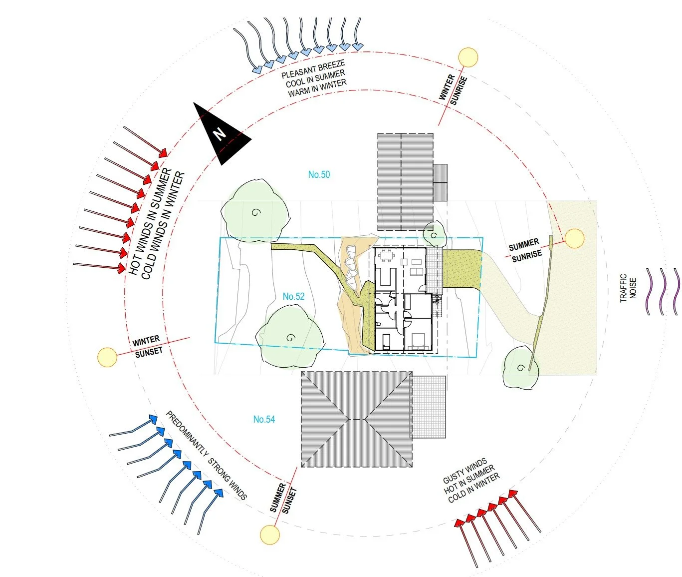
Gathering site information is crucial for this process and includes examining the geographical, geological surrounds, and unique viewpoints. A site visit is a great starting point, and registered surveyor can follow up to get some site-specific data.
Site Information Gathering
Geographical Analysis: Collect data on the site’s location, topography, and access to transport networks. This provides context for the site’s usability and potential for development.
Environmental Assessments: On-site visual analysis usually provides the most important information. You get a feel for the site, where the sun is moving, what will impact access to light and prevailing winds
Land Use and Zoning: Understanding existing land uses and zoning regulations is essential. This helps to identify what can legally be constructed on the site and ensures compliance with local development control plans (DCP’s).
Historical Use: Investigating the site's historical usage may reveal previous activities that could affect present conditions, including contamination risks or heritage considerations.
Planning Certificate
A Planning Certificate (Section 10.7) is obtained, providing crucial site constraint information
Detailed Site Survey
A registered surveyor will get provide detailed information about the subject site, generally including:
Identification of cadastral boundaries
Datum for grid co-ordinates to be on Map Grid of Australia (MGA) & all levels recorded to
Australian Height Datum (AHD)Site Benchmark placed (AHD)
Spot levels and contours, typically at 250mm intervals
Location of all visible Public Utilities within the vicinity of the work area
Locate all services, buildings, structures and fencing within the work area
Location of any existing trees showing height spread and trunk width
Adjoining properties building footprints within three (3) meters of the subject property
boundaries including ridge and gutter heightsRoad feature survey of the road fronting the subject lot to top of kerb
STEP 02: CONCEPT
If the project requires any existing elements to be kept, like an extension project, a detailed measure-up then takes place. Using a combination of software, a laser measure, and a trusty tape measure, all important existing measurements a noted to be reproduced in CAD. By integrating the existing building measurements with the detailed site survey (form Step 01 above) the Conceptual Design process can begin.
Existing Building(s) Measurements
Internal measurements of all rooms, ceiling heights, floor levels & fixed furniture (e.g. Kitchens)
Door and Window measurements, opening types noted
Wall thicknesses
Stair measurement (internal): treads, risers & flight patterns
Patio/decks & relevant hardstand measurements
Concept Design
CAD Model - site terrain, existing building(s) & neighboring buildings
Drafting in the planning barriers such as minimum setbacks & maximum building height limits
Mud-mapping & Mass Modelling - zoning the footprints of proposed spaces
Sketches - using the site analysis information, client style preferences and precedent research to express form
Preliminary Floor Plans
3D Concept model - CAD virtual models & 3D Printed

STEP 03: DETAILED DESIGN
With some broader design decisions made, we can narrow in on the specifics of the built form. The detailed design process is where you will start to see the final room sizes on the final floor plan and the building materiality is built up in elevation. From the outset, exterior materials are considered, but during the detailed design phase, they documented. The proposed elements of the project are clearly delineated and documented to form the DA plan-set, ready for lodgement.
Developed Design
CAD Model updated in 3D to show proposed VS existing work
2D Documentation: elevations, sections and 3D perspectives
Final design is settled on.
DA Plans
Site Plan: showing proposed area of development on the site
Floor Plan(s): showing existing, demolition and proposed building works
Roof & Stormwater Plan(s): demonstrating drainage from proposed roof design
Elevations: this is the side view, showing the external appearance including doors, windows and roof
Sections: a cut-through view, showing the interior spaces and associated structure
Compliance Tables & Schedules: door, window & wall details
3D Perspectives
Photorealistic Rendered Images
Additional Plans (as required)
Shadow Diagrams
Gross Floor Area (GFA) Calculations to demonstrate Floor Space Ratio (FSR)
Pool Compliance Plans
Landscape Plans

STEP 04: PLANNING APPROVAL
At this stage, you will need to prepare some accompanying documents form your overall Development Application (DA). Design for Place works closely with a planning consultant to gather your documents, and complete the lodgement on your behalf - this is an optional service, but simplifies the process. There are usually further checks needed to gain approval, so some external consultants may need to be engaged to complete the checklist of required documents. Once gathered and submitted online, your DA will be assessed.
Consultants (typically required)
BASIX Consultant: to provide a BASIX certificate and/or NatHERS Assessment and stamped building plans summarising BASIX commitments
Planner: to produce a Statement of Environmental Effects (SEE) report
Other Consultants (site & project specific)
Bushfire Consultant: if your site is located in a bushfire zone
Flood Certificate and/or Hydraulic Engineer: if your site is located within a flood zone
Note: this is generally identified at the start when we obtain the Section 10.7 Planning Certificate
Development Application (DA)
You (or our planning consultant) will need to lodge an application through the Online Planning Portal and apply for a Development Application (DA)
Council will generate a DA-fee specific to the project at this stage
Council will generate a Requests for Information (RFI) if further details in any aspect of the lodgement is missing/required
STEP 05: BUILDING APPROVAL
Once your DA is approved, or you are eligible for a fast-tracked CDC application instead, you will need to develop the building documentation further. This is to demonstrate compliance to the National Construction Code (NCC) and relevant Australian Standards. This information is provided to the certifier (PCA) for assessment. Typically, this step requires structural assessment by a qualified structural engineer, then we can provide detailed working drawings or construction plans. We will work with the engineer to co-ordinate the proposed structural design into the CAD model and the building design plans, to troubleshoot any functionality clashes that may arise.
Engineering
Structural Engineer: structural design of the proposed, approved building relative to associated site’s soil type & surrounds
Geotechnical Analysis: Soil condition report
Hydraulic/Civil engineer (if required)
Working Drawings (Construction Plans)
Building Specifications
Set-Out plans
Reflected Ceiling Plans - plumbing & electrical
Roof & Stormwater Plans
Detailed Elevations & Sections, annotated with references to legend(s)
Construction Details
Interior Elevations
Interior Design: FF&E Schedules, material palette & annotations
Stair Detailing
Construction Certificate (CC) or Complying Development Certificate (CDC)
Application through the Online Planning Portal and apply for a Construction Certificate (CC)
or Complying Development Certificate (CDC)
Certifier (PCA) to be appointed

STEP 06: BUILDING WORKS
Time to appoint your builder for the job. Design for Place works with many local reputable builders, and can provide suggestions for a variety of project types. For owner-builders, Design for Place can suggest individual trades as needed to assist with the coordination of your construction sequence. It is important for the builder to actively engage the certifier (PCA) for critical-stage and mandatory inspections.
Your Builder
You will need to decide on an agreed contract price with your chosen builder and engage them in advance to ensure your construction timeline runs smoothly
Builders should coordinate with the certifier (PCA) for inspections during construction
The builder should get in touch with Design for Place if any additional plans are required to assist with the build.

STEP 07: COMPLETION
When your building work is completed, it is time to enjoy your new space! You (or our planning consultant) will need to lodge one final application through the Online Planning Portal and apply for an Occupation Certificate (OC). After your final inspection is approved your OC will be issued by the certifier. Your development is now officially finalised.
Occupation Certificate (OC)
Obtained after the final PCA inspection is approved and any outstanding items have been finished by your builder
Development has been officially completed
